Without a doubt, it is appropriate to state that our survival lies in the future of agriculture. Without new developments that allow farmers to intensify their agricultural production, the conjunction of demographic trends in rising populations, increasing demand for food and ageing farmers create the possibility of an unfavourable global fate. And aside from the questions of current costs and whether automation technology enhances or disrupts the farming populations of specific nations, it is obvious that general technological improvements are a necessity.
Fortunately, great leaps are currently being made to continuously magnify our agricultural capabilities through providing farmers with a new
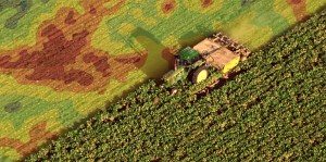
Drones have multiple uses that are currently being used to revolutionize agriculture and boost production. In order to understand their contributions the definition of drones needs to be established: they are unmanned aerial vehicles that are often equipped with complementary technologies such as cameras, and heat and light sensors.
An example of their uses can be seen within precision agriculture, which is the process of determining which crops are best suited to certain soil qualities and geological conditions for the express purpose of increasing farm yields. This type of agriculture is perfectly suited to the information gathering capabilities of drones, and has great implications for food; if farmers have increased knowledge on which crops are best grown in certain conditions, the quality of output will increase and unnecessary losses will decrease.
Drones offer practical methods in this task; high-resolution cameras on drones can be used to capture imagery and data of thousands of hectares of farms. This data can be used to map and address damage and crop stress, as well as predict per hectare yield. Additionally, drones can be flown to create what is known as normalized difference vegetative index maps, which detect dry spots and assess the soil quality.
With this information, crops can be differentiated from soil and forest, and the detection capabilities can be even more specific: sick and healthy plants can be told apart, as stressed and dehydrated plants reflect light in distinctive patterns. Drones can generate images using sensors that detect specific wavelengths of light absorbed and reflected by crops, and with this knowledge farmers are able to concentrate more effort on crops that need the extra attention, that would otherwise have gone without detection, and thus increase the quantity and quality of their overall yield.
Furthermore, drones can be used to warn against traveling airborne pathogens before they even begin affecting crops. Rather than intensification and specialization, this is primarily concerned with disease prevention, which has its own effects on efficiency.
The magnitude of this can be illustrated through what is surprisingly only a minuscule example in terms of annual crop destruction: global wheat losses due to a fungal disease known as wheat rusts alone are approximated to be 5 million USD per year. Considering that this is the destruction of only one crop by one pathogen, these losses are astounding. The detection of pathogens before they arrive can allow farmers and governments to prepare for their presence and significantly reduce this number.
The exciting realization is that drone technology allows farmers to know what is going on, the status of their farms, the likely outcome of their crops, without even stepping foot within the physical boundaries of the farm. It gives them more knowledge than they would have had access to in the past, from less than an ounce of the relative effort that it would have taken to survey the same amount of cropland if it was even attempted.
Drones are essential to make the business of farming more efficient, and future drones will only see rapid improvements in technology. The promises offered can be expressed in monetary terms: in 2015 the global market for agricultural drones was USD 670 million, and within the next five years it is expected to reach a compound annual growth rate in the double digits.
In other words, the market is expected to grow tremendously, and their increasing usage in agriculture is but one example of how technology can afford us more knowledge without the undertaking of labor and time intensive tasks.
Two natural complements to drone technology in the challenge to assure future food security are Geographic Positioning Systems (GPS) and Geographic Information Systems (GIS). GIS is a tool to combine the gathering, storage, manipulation, analysis and presentation of data and it is a relevant system in all location-based situations. With the combination of this technology data assembled by drones in vegetation, topography and weather-related phenomena could be developed into maps through GIS for more informed decision-making.
An example of using GIS in farming is Taylor Shellfish Farms, located in Washington, US. They use GIS software created by ESRI, a well-known developer and supplier. In the context of agriculture, it provides software that can combine imagery, field observations and real-time data to provide insight on maximizing finite natural resources, such as the availability of land.
For Taylor Shellfish Farms, features such as ESRI’s ‘Drone to Map’ utilize maps and layers of collected data to show farmers the prime farming areas for each shellfish species, based on chosen characteristics such as tide elevation and other environmental factors. With this information, the GIS software is able to give real-time recommendations to Taylor Shellfish Farms on the maximum utilization and expansion of existing farm locations.
In general, GIS is important in farming because it allows for real-time visualizations based on constant incoming data; farmers can select the data they wish to use, depending on whichever factors are situationally relevant, easily manipulate the data through GIS software and reach answers with an equal or higher precision and accuracy than otherwise possible.
GIS software can be tailored to any location-based question, whether it’s where to locate a farm, where to expand, which soils are most suitable to certain crops, which areas experience the most unstable weather, which locations are most profitable based on distance from the market, and more. In essence, it is a tool that can be used by farmers to make knowledgeable decisions based on abundant data.
In the past, extracting the same knowledge and mapping farmland would have been a sizeable task. In the present, the combination of collecting location-based information using drones and GPS, and transforming this information into knowledge that can be applied to increase the efficiency of farming using GIS means farmers can reach frontiers that had previously been thought not possible.
This is yet another example of what technology has to offer us as a society. Both technology and the human ingenuity behind it’s creation play an integral role in agriculture and food, and our continued utilization of both these commodities today can allow us to fulfil the requirements for securing our future.